In the fast-paced world of aviation, accuracy and safety are critical. Accurate and current geographical information is critical to the aviation industry’s ability to navigate and plan operations. The Aerodrome Mapping Database (AMDB) is a crucial element in this situation. Aeronautical information management relies on this advanced tool, which has its roots in the GIS (Geographic Information System) business, to ensure safe and effective air travel.
Understanding Aerodrome Mapping
GIS Integration in Aviation:
GIS is a potent technology that is widely used in the aviation industry. It is capable of capturing, analyzing, and presenting geographic data. The handling of spatial data has been completely transformed by incorporating GIS into aeronautical information management. A subset of GIS called the Aerodrome Mapping Database is dedicated to thoroughly mapping aerodromes, offering a precise and in-depth depiction of airport elements.
Aerodrome Mapping Components:
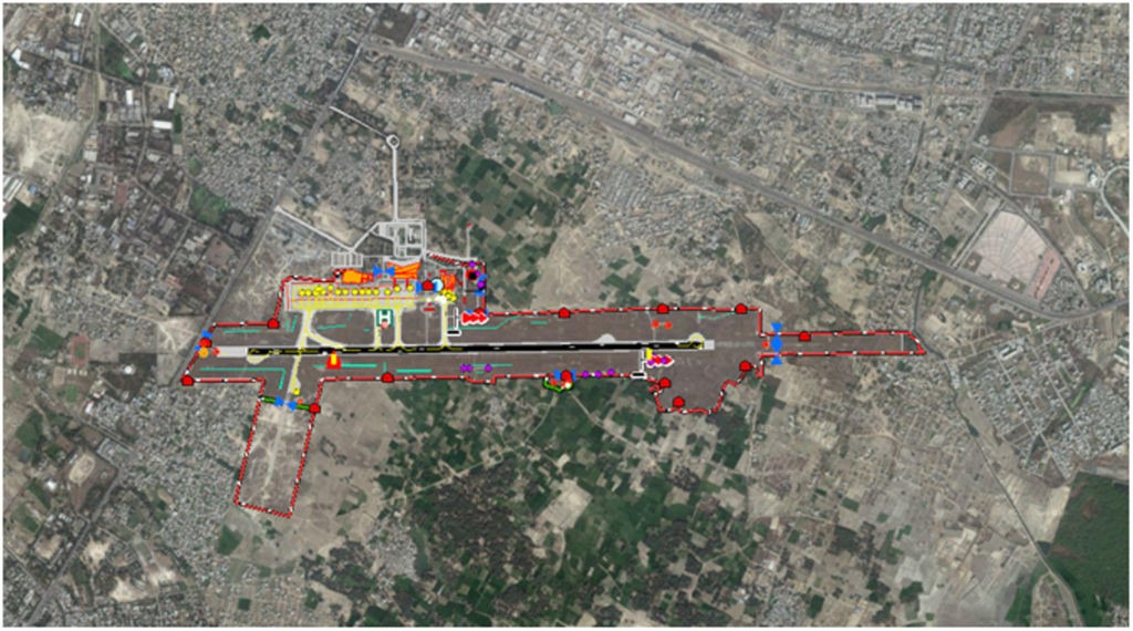
- Runways and Taxiways
The accurate mapping of taxiways and runways is a crucial component of the Aerodrome Mapping Database. With the aid of GIS technology, intricate plans can be produced, complete with runway measurements, orientation, and taxiway routes. Pilots need to know this information when taking off, landing, and taxiing.
- Parking stands and aprons
Another essential element documented in the database is the apron, which is the area where airplanes are parked, loaded, and unloaded. GIS makes it easier to identify and categorize parking spots, which guarantees effective space use and streamlined ground operations.
- Surface Obstacles
With the use of GIS, airport obstacle surfaces can be identified, guaranteeing that no buildings or other natural features could endanger aircraft during takeoff or landing. For risk management and safety compliance, this thorough mapping is crucial.
- Lighting at Aerodrome
Comprehensive data about aerodrome lighting systems can be found in the Aerodrome Mapping Database. This includes the positioning and features of lighting fixtures such as taxiway lights and runway lights that are essential for low-light operations and nighttime operations.
- Aids to Navigation
Mapping navigational aids like Instrument Landing Systems (ILS), Very High-Frequency Omni-Directional Range (VOR) stations, and Distance Measuring Equipment (DME) is made possible thanks in large part to GIS technology. Precise aircraft navigation depends on the accurate portrayal of these aids.
Features of Aerodrome Mapping Database
Precision in Geometry: The AMDB meets industry standards like ICAO Annex 4, which outlines the necessary accuracy for airport mapping, by ensuring high precision in spatial data.
Information Model (Features): Makes use of a strong data model with discrete feature classes for runways, taxiways, aprons, buildings, and navigational aids, among other aerodrome components.
Integrity of Topology (Topology Rules): Complies with topological rules to preserve the connectivity and spatial relationships among various airport features, guaranteeing data integrity.
Information about Attributes (Metadata Standards): These standards enable the description and documentation of attributes in metadata, hence promoting interoperability and comprehension of data.
Dynamic Components (Time-sensitive Data): Contains the capacity to handle dynamic components like construction zones, temporary roadblocks, and other time-sensitive data pertaining to airport modifications.
Importance of Aerodrome Mapping Database’s Importance
Compliance with regulations and safety:
In aviation, safety is the primary priority, and the Aerodrome Mapping Database is essential to maintaining it. The database helps ensure aircraft navigation is safe by offering precise and thorough spatial data. Moreover, it conforms to international aviation standards, such as those established by the International Civil Aviation Organization (ICAO).
Effectiveness of Operations:
The foundation of operational efficiency at airports is precise geographical data. The Aerodrome Mapping Database provides accurate information that pilots, air traffic controllers, and ground crew depend on to ensure efficient and well-coordinated operations. Using this information facilitates quick reactions to emergencies, efficient ground movements, and the best utilization of the runway.
Planning for Emergency Reactions:
It is essential to make decisions quickly and intelligently in emergency situations, such as airplane mishaps or unfavorable weather. The Aerodrome Mapping Database improves the efficacy of emergency response plans by giving emergency responders access to comprehensive geographic information, such as firefighting equipment locations, emergency exits, and access routes.
Upcoming Developments in Aerodrome Mapping
Automation and AI Integration:
Automation and artificial intelligence (AI) integration are key components of the Aerodrome Mapping Database’s future. Automated procedures for gathering, verifying, and updating data will increase productivity and lower the possibility of mistakes. Artificial intelligence (AI) algorithms can aid in the study of complicated spatial data by providing insights that improve decision-making.
Visualization and 3D Mapping:
Aerodromes may now be mapped and visualized in three dimensions (3D) thanks to developments in GIS technology. This helps to clarify the spatial relationships between various parts and offers a more realistic picture of airport layouts. Training programs and flight simulators benefit greatly from 3D mapping.
Streaming Data in Real Time:
The need for up-to-date information in the aviation industry is growing. The Aerodrome Mapping Database’s integration of real-time data streaming capabilities enables instant updates on changing conditions, guaranteeing that all stakeholders have access to the most recent information. This is particularly important when hasty decisions are required.
At the nexus of GIS technology and aviation, the Aerodrome Mapping Database is a vital tool for improving safety, productivity, and decision-making within the sector. The capabilities of this indispensable instrument will advance along with technology. The Aerodrome Mapping Database has a bright future ahead of it, one that will guarantee that the skies are safe and compassable for future generations. From precise runway and taxiway mapping to the incorporation of automation and artificial intelligence.


