At a time when technology continues to redefine human capabilities, satellite imagery stands out as a crucial tool in disaster management. Satellite imagery and unmanned aerial vehicles (UAVs) have revolutionized disaster preparation, response, and recovery through the convergence of high-resolution satellite imagery. It plays a substantial role in disaster management, focusing on flood mapping, terrain modeling, and broader implications for geospatial industries.
Due to its ability to provide real-time information, comprehensive coverage, and a bird’s-eye view of affected areas, satellite imagery has become an indispensable asset in disaster management. Particularly high-resolution satellite imagery has helped authorities assess the extent of damage, plan response strategies, and allocate resources more effectively.
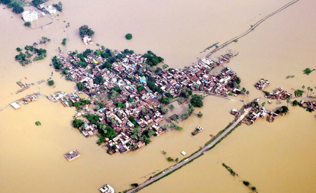
Flood mapping is one of the most important uses of satellite images in disaster management. Satellite technology can be used to successfully monitor and manage floods, a frequent and catastrophic natural calamity. Authorities can quickly and accurately map flooded areas by using high-resolution satellite images, which makes it possible to identify high-risk locations and arrange evacuation routes.
Images taken by satellite sensors during a flood event are used to produce maps of the flood’s extent. These maps include important details on the places that are impacted, the water level, and the rate of flooding. Emergency responders can use this information to prioritize regions that require immediate care, plan rescue operations, and allocate resources more wisely.
Drones or unmanned aerial vehicles (UAVs) offer a more granular and focused picture of disaster-affected areas than does satellite imaging, which gives a broad overview. Drones can be quickly deployed into regions that are too risky or inaccessible for ground teams to access in order to gather real-time data.
These unmanned aerial vehicles are essential for disaster reconnaissance since they are fitted with high-resolution cameras or sensors. Drones can swiftly analyze the scene, identify survivors or casualties, and communicate this information to emergency crews in disaster response scenarios. UAVs can also be used for post-disaster damage assessment, which aids authorities in comprehending the effects on residential regions, vital facilities, and infrastructure.
Not only is satellite imagery useful for evaluating the damage caused by natural catastrophes, but it is also essential for anticipating and making plans for future emergencies. Using satellite imagery for terrain modeling, which entails building three-dimensional depictions of landscapes, is a useful tool in disaster management.
Geospatial experts can model terrains and identify places susceptible to particular natural disasters, such flash floods or landslides, by studying satellite data. By taking a proactive stance, authorities can fortify infrastructure, carry out preventive actions, and create evacuation plans for areas that are at risk.
Offering a comprehensive and dynamic toolkit for assessing, responding to, and limiting the impact of natural disasters, satellite imagery has emerged as a game-changer in disaster management. The utilization of high-resolution satellite imagery in conjunction with other technology, such as drones, has greatly enhanced our capacity to comprehend and tackle the difficulties presented by natural disasters, ranging from mapping floods to modeling topography.
The combination of cutting-edge technologies and satellite imagery will be crucial in forming more efficient disaster management plans as the geospatial industry develops. By combining precise aerial photos, real-time data, and predictive modeling, decision-makers are able to save lives and lessen the socioeconomic effects of natural catastrophes.


