Farmers have always been at the forefront of technological innovation in agriculture, looking for new and creative ways to maximize crop yields, reduce their environmental impact and guarantee food security. Geographic Information Systems is a ground-breaking technology that has completely changed the agricultural environment where farmers and agricultural professionals may analyze data, make decisions and manage resources more effectively using GIS in agriculture, also known as agriculture mapping.
In order to shed light on intricate spatial interactions, the multidisciplinary area of geographic information systems incorporates geographic data, modern mapping techniques and spatial analysis. A wide range of applications such as crop planning, soil analysis, irrigation management, pest control and yield monitoring are included in GIS for agriculture to maximize different areas of farm management.
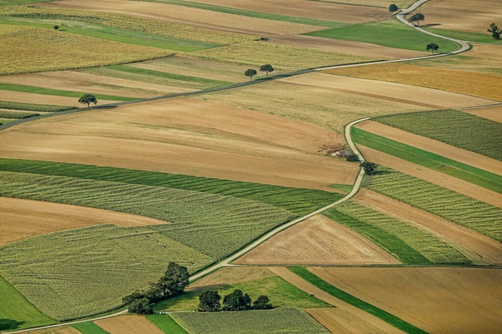
Spatial data connected to particular geographic areas is the fundamental component of agriculture mapping where aerial surveys, GPS-enabled devices, ground-based sensors, satellite imaging and historical documents are some of the sources from which this data may come. These spatial data are combined and analyzed by GIS platforms to produce useful insights that enable farmers to make defensible decisions.
GIS Maps for Agriculture
GIS maps have revolutionized agriculture by offering precise spatial data analysis and through remote sensing and GPS technology, GIS maps provide farmers with essential information for optimizing crop management. Utilizing layers such as soil type, elevation and vegetation indices, farmers can make informed decisions on irrigation, fertilization and pest control. GIS aids in monitoring crop health, detecting anomalies and assessing yield potential.
Furthermore, it facilitates precision farming techniques like variable rate application and with the integration of real-time data and predictive modeling, GIS maps empower farmers to enhance productivity while minimizing environmental impact marking a pivotal advancement in modern agriculture.
Precision Agriculture Mapping
A key component of contemporary farming, precision agriculture mapping uses Geographic Information Systems to analyze land with great care where it accurately marks fields using GPS technology maximizing resource use and raising crop production. Remote sensing and spatial analysis are two GIS technologies that provide in-depth information on the composition of soil, moisture content and health of vegetation.
Farmer decision-making on irrigation, fertilization and pest management is facilitated by the integration of data from sensors, drones and satellites and with this clever strategy, waste is reduced, productivity is increased and sustainable farming methods are promoted. The use of GIS technology in precision agriculture is still essential for both environmental stewardship and agricultural productivity as it develops.
Green Vegetation Indices (NDVI Maps)
Geospatial Information Systems rely heavily on green vegetation indices including the Normalized Difference Vegetation Index (NDVI) to evaluate the health of the vegetation. NDVI maps measure the difference in reflectance between near-infrared and red light from satellite data to estimate the density and vigor of vegetation. Higher values on this measure which has a range of -1 to 1 to indicate healthier vegetation. GIS experts use NDVI maps to track crop health, evaluate changes in land cover and identify environmental deterioration. These maps offer priceless insights for ecological research, precision farming and land management enabling well-informed decision-making for conservation and sustainable resource management.
GIS-enabled agriculture mapping offers a comprehensive approach to resource management, precision agriculture and decision assistance, thereby redefining contemporary farming methods. Farmers may achieve unprecedented levels of productivity, sustainability and resilience in the face of changing agricultural challenges by utilizing the potential of spatial data analysis. GIS integration will become more and more important in determining how food production and global food security develop in the future as the agriculture sector embraces innovation.


