SpacEyes3D

SpacEyes3D

SpacEyes3D is a software suite to professionals who wish to enhance and present a particular territory in 3D. SpacEyes 3D is an easy-to-use and convenient tool for creating, from existing vector and raster data, and distributing high-quality three-dimensional models of unlimited size.

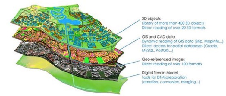
SpacEyes 3D allows you to use existing graphics data (digital terrain model (DTM, grid), GIS vector layers, remote sensing raster data (aerial and satellite images), complex 3D objects (AutoCAD, 3D Max, Google Earth) without alphanumeric conversion, alphanumeric data) in order to collect from them a realistic three-dimensional model of the territory and the project for subsequent distribution and demonstration in the “flyby” mode in real time, including using virtual reality (stereo glasses or a helmet).
SpacEyes 3D can import a large number of data formats and export the created model to high-quality bitmap images and animations, create an autonomous three-dimensional model or publish it on the Internet, use the management and analysis functions of the information-spatial model.

The SpacEyes3D software is structured in:

  • SpacEyes3D “Builder” to build the 3D territorial models,
  • SpacEyes3D “Viewer” to consult the models,
  • SpacEyes3D “Server” for their distribution on Internet or Intranet,
  • SpacEyes3D “SDK-Plugin” to integrate SpacEyes3D technology into custom applications (desktop or web).