Using Unmanned Aerial Vehicles (UAVs) or drones to map agricultural landscapes and gather spatial data, drone agriculture mapping entails taking high-resolution aerial photos. Many sensors such as multispectral, hyperspectral and LiDAR (Light Detection and Ranging) sensors which collect data outside of the visible spectrum are installed on these drones. Drones gather enormous volumes of georeferenced data by flying over fields at preset heights and trajectories and this data provides in-depth insights into crop health, soil conditions, water distribution and pest infestations.
Precision farming has revolutionized the agriculture industry in recent years by utilizing cutting-edge technologies to maximize sustainability, resource management and productivity where drone mapping for agriculture has become a potent tool among these technologies transforming conventional farming methods. Drones with high-resolution cameras and sensors can be used to use the power of Geographic Information Systems to give farmers unprecedented field insights allowing for targeted interventions and accurate decision-making.
Technical Components of Drone Agriculture Mapping
Remote Sensing Sensors: Drones come carry a range of remote sensing instruments that are designed to collect particular kinds of data. For example, multispectral sensors record images at several wavelengths making it possible to evaluate the stress and health of the vegetation. Even higher spectrum resolution is possible with hyperspectral sensors allowing for a thorough examination of plant physiology and biochemical characteristics. High-resolution elevation models are produced by LiDAR sensors using laser pulses where these models are crucial for drainage analysis and terrain mapping.
Global Positioning System (GPS): GPS stands for global positioning system and it is a technology that allows drone data to be precisely geolocated guaranteeing perfect spatial referencing and alignment with pre-existing GIS datasets. Drones may follow predefined flight paths with centimeter-level accuracy by integrating GPS data with onboard flight controllers which maximizes coverage and data consistency.
Photogrammetry Software: This type of software uses drone imagery to create digital elevation models (DEMs), orthomosaic maps and three-dimensional (3D) reconstructions of agricultural landscapes. These technologies use complex algorithms to extract geometric information, fix distortions and stitch together separate images so that volumetric analysis and exact measurements may be performed.
GIS Software: The analysis and interpretation of data obtained by drones heavily rely on GIS software where a variety of spatial analysis techniques such as picture categorization, geographical interpolation and suitability modeling are available on platforms including ArcGIS, QGIS and ENVI. Farmers may discover spatial patterns, establish management zones and prioritize actions based on spatial variability by superimposing drone imagery over pre-existing GIS layers.
Applications of Drone Agriculture Mapping
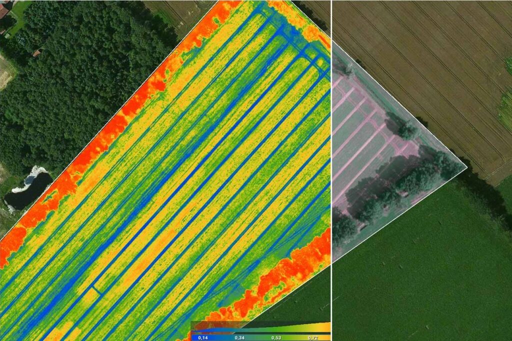
Crop Health Assessment and Monitoring: Real-time crop health and vigor monitoring is made possible by drone photography which also helps with early disease, nutrient and insect infestation detection. Farmers can monitor biomass accumulation, detect stress regions and undertake focused remedial actions including precision spraying or localized fertilization by creating vegetation indices like the Normalized Difference Vegetation Index (NDVI).
Soil Mapping and Analysis: Drones fitted with LiDAR scanners and soil sensors can map and analyze soil giving researchers important information about the composition and characteristics of the soil. Drone data-derived maps of soil moisture help regulate irrigation, maximizing water use and reducing runoff and soil fertility maps allow fertilizer to be applied at a variable rate matching nutrient inputs to crop needs and soil requirements.
Yield Prediction and Optimization: Farmers can create predictive models for agricultural yield estimation by combining machine learning algorithms with data collected from drones. These models take into account several variables, including crop phenology, weather and soil properties enabling farmers to optimize harvest logistics and planning by anticipating variations in output.
Environmental Monitoring and Compliance: By making it easier to comply with legal requirements and sustainability standards, drone agriculture mapping promotes environmental stewardship and through the monitoring of land use changes, water quality and habitat fragmentation, farmers can both demonstrate their commitment to conservation principles and reduce environmental repercussions.
Agriculture Mapping Software
Precision farming relies heavily on agriculture mapping software which uses Geographic Information Systems technology to manage land as efficiently as possible and with the integration of topographic, meteorological and soil-type data, this software helps farmers make accurate decisions. It enables targeted applications of pesticides, fertilizers and irrigation increasing efficiency and sustainability where layers like as NDVI images, soil fertility maps and yield data are utilized.
By utilizing sophisticated methods for spatial analysis like as suitability modeling and interpolation, farmers can maximize yields while minimizing risks through crop location and selection optimization. A new era of data-driven farming is being ushered in by agriculture mapping software which embodies the integration of GIS technology with agricultural methods.
GIS-enabled drone agriculture mapping has become a key component of contemporary precision farming where drones help farmers make data-driven decisions, optimize their use of resources and maintain environmental sustainability by giving them access to previously unobtainable geographical insights. Drones and GIS integration have the potential to create an agricultural industry that is more productive, robust and efficient as technology continues to change the agricultural environment. By embracing this paradigm change, farmers can confidently and precisely handle the challenges of contemporary agriculture ensuring future generations’ access to food and environmental stewardship.


