What is LiDAR in GIS?
GIS has seen a revolution in technology with the emergence of LiDAR, or Light Detection and Ranging. LiDAR, which uses laser light to measure distances extremely accurately, is becoming a vital technique for gathering extremely comprehensive geospatial data. This article examines the complexities of LiDAR technology, the subtleties of LiDAR data, and the complex procedures used by the GIS sector to process LiDAR data. Using laser beams to estimate the distance between the sensor and the target surface, LiDAR works on the active remote sensing principle. The LiDAR sensor, mounted on an aircraft or ground-based platform, releases laser pulses reflected off objects and then back to the sensor, allowing for accurate distance readings. The basis of LiDAR data is the resultant point cloud, which is made up of millions of 3D coordinates.
LiDAR data usually consists of the following essential elements:
Point Clouds: Point clouds are the basic units of LiDAR data; they are made up of discrete points in three dimensions, each of which represents a distinct place on the surface of the planet.
Intensity Values: By encapsulating the reflected laser energy, the intensity values linked to every point in the cloud improve the LiDAR data’s interpretability.
Return Types: LiDAR pulses can have a variety of returns, each of which can provide details on the surface properties. First returns (top of the canopy or terrain), last returns (bottom of the canopy or terrain), and intermediate returns are common return types.
Information about Georeferencing: A LiDAR dataset’s points are all georeferenced, enabling precise spatial location inside the Earth’s coordinate system.
LiDAR applications for GIS
Professionals’ ability to analyze and depict geographic data has been revolutionized by LiDAR technology thanks to its adaptability, which has accelerated its incorporation into a variety of GIS applications. Among the important applications are:
Terrain Modeling: Because of LiDAR’s extreme precision, precise digital elevation models (DEMs) and terrain models may be produced. This is important for applications like landform characterization, slope analysis, and mapping floodplains.
Forestry and Vegetation Analysis: LiDAR is useful for determining biomass, analyzing vegetation structure, and evaluating the health of forests. It makes it possible to analyze canopy height, density, and structure in great detail.
Urban Planning and Infrastructure Management: LiDAR provides comprehensive data on buildings, roads, and other infrastructure components, which helps in urban planning. It is useful for managing utility networks, keeping an eye on urban growth, and evaluating land usage.
Floodplain Mapping and Hydrology: River channel mapping, floodplain delineation, and hydrological process modeling are all made easier with the use of LiDAR. Precise flood risk assessment is facilitated by precise elevation data obtained from LiDAR.
GIS-Based LiDAR Data Processing
In its unprocessed state, LiDAR data is a vast array of points from which valuable information must be extracted. The standard method for processing LiDAR data is outlined in the following steps:
Obtaining and Preparing Data:
a. Flight Planning: Careful flight planning is necessary to provide optimal coverage and high-quality data before data collection.
b. Sensor Calibration: Accurate distance readings are ensured by calibrating the LiDAR sensor to take into account variations in the angle of the laser beam.
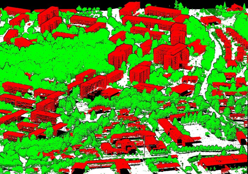
Classification of Point Clouds:
a. Ground Filtering: It’s important to separate ground points from non-ground points. Progressive morphological filters are one type of algorithm that aids in precisely identifying terrain surfaces.
b. Vegetation Classification: Applications in forestry are aided by the classification of sites as vegetation or non-vegetation. LiDAR data makes it possible to analyze canopy density and structure in great detail.
Integration of Data:
a. Combining LiDAR with Other Data Sources: LiDAR data becomes more useful when it is integrated with other geospatial information. For instance, merging satellite photos and LiDAR data offers a thorough perspective of the terrain.
Feature Deletion:
a. Building Extraction: LiDAR data may be automatically processed by algorithms to detect and extract building footprints, which makes infrastructure management and urban planning easier.
b. Road and Transportation Network Extraction: Road networks may be located and mapped using LiDAR data, which helps with transportation management and planning.
Information Visualization:
a. Immersion visualization is made possible by the intrinsic 3D nature of LiDAR data. The capacity of GIS specialists to produce intricate 3D representations of landscapes improves the interpretability of geographical data.
b. Orthophoto Generation: Accurate orthophotos are produced by combining LiDAR data with high-resolution photography, which enhances the way the terrain is depicted visually.
Validation and Quality Control:
a. Accuracy Assessment: Strict quality control procedures, such as statistical validation and ground truthing, guarantee the accuracy of processed LiDAR data.
b. Error Correction: Ensuring data integrity requires the identification and correction of flaws in LiDAR data, such as misclassifications or outliers.
Upcoming Patterns
Progress in Sensing Technology:
a. Miniaturization: As LiDAR sensors get smaller and lighter, more platforms—such as drones and small satellites—can use them, lowering costs.
b. Multi-Sensor Integration: By integrating LiDAR with thermal or hyperspectral sensors, for example, geographical data becomes richer.
Artificial Intelligence & Automation:
a. Automated Processing: LiDAR data processing is becoming more efficient thanks to machine learning techniques, which automate processes like feature extraction and point cloud classification.
b. Deep Learning for Classification: Particularly in intricate settings like cities, deep neural networks are increasing the precision of point cloud classification.
Open Data Projects:
a. Data Sharing and Collaboration: Through the sharing of LiDAR datasets, open data initiatives are encouraging cooperation between academics, governmental organizations, and business personnel.
b. Community Involvement: Including nearby communities in the processes of gathering and validating data improves the accessibility of geographic data.
Because LiDAR technology allows for unprecedented precision in geospatial analysis, it has unquestionably become a cornerstone in the GIS business. LiDAR has many applications, from urban planning to terrain modeling. The incorporation of LiDAR data into GIS workflows is expected to become more widespread as technological improvements continue to reduce costs and improve automation. This will open up new avenues for comprehending and managing our dynamic and complex world. If GIS specialists want to use LiDAR technology to its fullest in their job, they must adopt these innovations.


