Geospatial technology has become a potent tool in the quickly changing technological landscape, revolutionizing our understanding of and interactions with our surroundings. The development and use of digital twins is one of the most fascinating uses of geospatial technology. With an emphasis on essential components like 3D building models, 3D city models, Digital Elevation Models (DEMs), and GIS mapping, this article examines the critical role that geospatial technology plays in creating digital twins. A variety of instruments and methods for gathering, processing, and visualizing spatial data are included in geospatial technology. This technology gathers and interprets geographic data using a variety of sensors, GPS units, and satellite imagery. A key element of geospatial technology is the GIS (Geographic Information System), which provides the digital framework for mapping and analyzing spatial data.
What is a digital twin?
Digital Twins: An Overview of Concepts – A digital twin is an electronic copy of a real-world item, procedure, or system. It is a dynamic replica that mimics real-world objects in real-time rather than just a static model. The notion of digital twins has become increasingly popular in a number of industries, such as manufacturing, infrastructure management, and urban planning.
Our capacity to model and comprehend the real world is changing as a result of the collaboration between digital twins and geospatial technology. Here are some ways that geospatial technology is essential to the development and improvement of digital twins:
- 3D Building Models: The Foundation of Architecture
A complex three-dimensional building model is the core component of many digital twins. Buildings can be accurately and in great detail represented in three dimensions thanks to geospatial technology. LiDAR (Light Detection and Ranging) technology, sophisticated mapping methods, and high-resolution satellite imagery are all used in this. A digital twin’s architectural framework is a 3D building model, which offers a realistic and engrossing experience. For urban planners, architects, and decision-makers to visualize and simulate scenarios ranging from urban development to disaster response, this level of detail is essential.
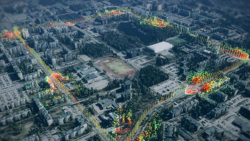
- 3D City Models: Getting Around in Urban Environments
Comprehensive 3D city models are made possible by geospatial technology, which broadens the focus beyond individual buildings. These models incorporate information about infrastructure, buildings, and natural features to capture entire urban landscapes. The end product is a comprehensive representation that makes it easier to manage infrastructure, improve public services, and plan urban areas. Through the incorporation of 3D city models into digital twins, stakeholders can examine how different factors affect the urban environment. This entails determining the efficacy of suggested modifications, comprehending traffic patterns, and allocating resources for utilities and emergency services as efficiently as possible.
- Terrain Dynamics: Capturing Digital Elevation Models (DEMs)
A vital part of geospatial technology that records the elevations of the Earth’s surface are digital elevation models. DEMs depict an area’s topography, including hills, valleys, and topographical changes, using elevation data. Particularly in situations like environmental monitoring, agriculture, and disaster management, this information is crucial for producing accurate and realistic digital twins. DEMs aid in the accurate depiction of the physical world in the context of digital twins. For example, they are essential in modeling the movement of water across a terrain, forecasting the occurrence of floods, or comprehending the effects of topographical modifications on urban growth.
- GIS Mapping: Connecting the Pieces
The foundation of geospatial technology is GIS mapping, which is also essential for creating and improving digital twins. Geographic Information Systems (GIS) facilitate the amalgamation and evaluation of heterogeneous spatial datasets, furnishing an all-encompassing perspective of the environmental and physical attributes of an area. GIS mapping facilitates a more nuanced understanding of the relationships between various elements in a digital twin by making connections between disparate data layers. This covers the interactions between structures, natural features, infrastructure, and socioeconomic variables. GIS mapping gives complex scenarios a spatial context, which helps with data-driven decision-making.
Utilizations in All Sectors:
The integration of digital twins and geospatial technology has broad implications for a variety of industries:
Urban Development and Planning:
With the use of geospatial technology, comprehensive 3D city models can be produced, giving urban planners the ability to examine and assess suggested changes to the urban environment. With the use of digital twins, different urban development scenarios can be simulated, assisting decision-makers in evaluating the effects on the environment, traffic, and infrastructure.
Infrastructure Supervision:
By offering a thorough grasp of the built environment, 3D city and building models facilitate effective infrastructure management. Digital twins help with predictive maintenance of infrastructure, which lowers downtime and improves overall performance.
Disaster Management:
Natural disasters like floods, earthquakes, and wildfires can be predicted and simulated with the help of digital twins that integrate digital elevation models. In times of disaster, geospatial technology’s real-time data facilitates quicker reactions and wiser decisions.
Environmental Surveillance:
Monitoring changes in the natural environment, such as deforestation, land degradation, and climate change, is made easier with the use of geospatial technology, including DEMs. Digital twins offer an all-encompassing perspective of the surroundings, supporting conservation initiatives and sustainable resource management.
Challenges and Upcoming Trends
Although there is a lot of promise for integrating digital twins and geospatial technology, there are some issues that must be resolved:
Interoperability and Data Integration:
It’s still difficult to ensure the smooth integration of various datasets from various sources. Setting up data interoperability standards is essential to building accurate and thorough digital twins.
Security and Privacy Issues:
Since digital twins incorporate real-time data from multiple sources, privacy and security issues must be properly addressed to avoid misuse and unauthorized access.
Scalability:
The ability of digital twins to expand to encompass larger regions or intricate systems necessitates constant improvements in processing speed and computing power.
User Instruction and Acceptance:
The intricacy of digital twin concepts and geospatial technology may make user adoption and education difficult.
One key component in the creation and advancement of digital twins has been the emergence of geospatial technology. Every element, from GIS mapping and DEMs to 3D building models, is essential to producing realistic, dynamic, and priceless virtual representations of the real world. The combination of digital twins and geospatial technology will revolutionize how humans plan, manage, and engage with our surroundings as technology develops, bringing in a new age of intelligence.


