Within the field of Geographic Information Systems (GIS), encroachment management and detection have emerged as critical responsibilities for land administration, infrastructure development, and urban planning. Maintaining accurate geographical data and ensuring the effective use of land resources are significantly hampered by encroachment, which is commonly described as unauthorized entry onto another’s property. The complexities of encroachment identification in the GIS sector are examined in this article, along with the technical approaches and state-of-the-art instruments used to locate, evaluate, and lessen encroachment.
Recognizing the Importance of Encroachment
In a GIS setting, encroachment is the term used to describe the unpermitted use or occupation of a land area, parcel, or property. This phenomenon can take many different forms, including trespassing, unlawful building, and the extension of construction outside of approved borders. It is imperative to detect and remove encroachments for multiple reasons:
Property Rights and Land Management: Establishing and defending land ownership rights depends on precise property boundary delineation. Encroachments require accurate detection and documentation because they might cause disagreements and legal complications.
Urban Planning: Encroachments can upset the balance of spatial arrangements and obstruct planned development in urban settings. The integrity of urban planning projects is contingent upon the adherence of structures to zoning restrictions.
Infrastructure Development: Projects involving utilities, transportation, and communication may be hampered by encroachments on approved infrastructure corridors. Encroachment detection and remediation are essential phases in guaranteeing the successful implementation of infrastructure projects.
Technical Underpinnings
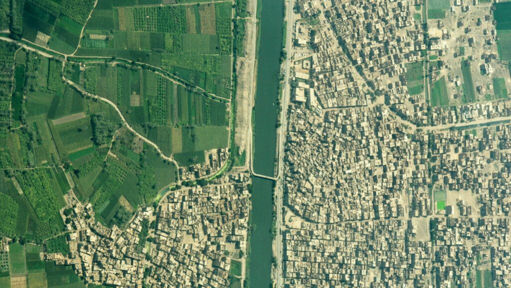
High-Resolution Satellite Imagery: High-resolution satellite imagery is one of the main instruments used to detect GIS encroachment. Contemporary satellite sensors offer fine-grained perspectives of topography, making it possible to discern alterations in land utilization and uncover unapproved constructions. Object-based image analysis (OBIA) and other automated image processing methods are essential for deriving valuable information from satellite data.
LiDAR Technology: Laser light is used in Light Detection and Ranging (LiDAR), a remote sensing technology, to detect distances. When combined with GIS, LiDAR data makes accurate three-dimensional landscape mapping possible. When it comes to spotting encroachments in regions with intricate topography and detecting minute variations in elevation, this technology is invaluable.
AI Algorithms and Machine Learning: The combination of AI and machine learning algorithms has transformed the field of incursion detection. The automatic detection of encroachments is made possible by the ability of these algorithms to be trained to identify patterns and abnormalities in spatial data. Support vector machines (SVM) and convolutional neural networks (CNN) are two examples of classification algorithms that have demonstrated impressive effectiveness in this area.
Geospatial Data Analysis: This type of data analysis looks at different data sets, such as cadastral, zoning, and land parcel information. GIS experts can spot irregularities and encroachments by overlaying these layers and carrying out geographical studies. For example, buffer analysis aids in determining how close structures are to property lines.
Global Navigation Satellite Systems (GNSS): GPS and other GNSS technologies offer precise location data that is necessary for verifying spatial information. Real-time monitoring and mapping made possible by GNSS and GIS integration facilitate the on-the-ground confirmation of encroachments detected by remote sensing technology.
Techniques for Detecting Intruders
Change Detection Analysis: To find changes throughout time, change detection compares various sets of geographic data. GIS experts can identify possible encroachments by identifying changes in land use or unpermitted buildings by examining historical satellite imagery or LiDAR data.
Cadastral Audits: To find discrepancies, cadastral maps and documents are systematically reviewed as part of cadastral audits. These audits, which are frequently enhanced by field surveys, assist in confirming property borders and locating encroachments that might not be visible from remote sensing alone.
Mobile GIS Applications: By using mobile GIS applications, field data collection is made easier. When conducting on-site inspections, GIS specialists with mobile devices can update spatial data in real-time and record encroachments. The timeliness and accuracy of the encroachment data are improved by this method.
Crowdsourced Data: Using crowdsourced data to identify intrusions may be useful in some circumstances. With specialized apps, citizens with smartphones may report such encroachments, giving GIS experts important information for additional investigation.
Case Studies in GIS Encroachment Detection
City Planning in Singapore: GIS technology is used by Singapore, a city-state renowned for its careful urban planning, to track land use and spot encroachments. The government makes use of LiDAR data and high-resolution satellite images to make sure that developments follow zoning laws, which helps to maintain the city-state’s orderly urban landscape.
Land Administration in Rwanda: To protect property rights and stop encroachments, Rwanda has successfully put in place GIS-based land administration systems. Rwanda has greatly decreased land-related conflicts and unpermitted land use through cadastral audits, satellite photography, and community involvement.
Future Trends in GIS
Several trends are influencing how incursion detection will develop in the future as GIS technology advances:
Integration of IoT Sensors: Real-time data on land use and environmental conditions can be obtained from Internet of Things (IoT) sensors. The dynamic monitoring of encroachments and improved response of detection systems are made possible by the integration of IoT data with GIS.
Blockchain for Land Records: Research is being done on using blockchain technology to manage land records transparently and safely. Blockchain can improve the integrity of GIS data by offering a decentralized, immutable ledger, which lowers the possibility of unwanted changes.
Advanced AI and Deep Learning: As AI and deep learning algorithms continue to progress, the accuracy of incursion detection will be further improved. With the use of these technologies, GIS systems will be able to automatically pick up on and adjust to changing land use trends.
In the GIS sector, encroachment identification is a complex task that calls for a combination of state-of-the-art technologies, reliable procedures, and a thorough comprehension of ethical and legal issues. Global landscapes are being continuously altered by urbanization and infrastructure development, making GIS an indispensable tool for managing and protecting land resources. GIS specialists may make a substantial contribution to the equitable and sustainable use of land by adopting new ideas and staying up to date with technology improvements. This will ultimately lead to the development of well-planned and resilient communities.


