With the introduction of innovative technologies, the agricultural landscape has undergone a dramatic transition in recent years and the use of drones in agriculture is one such innovation that has become rather popular. Precision agriculture has been ushered in by unmanned aerial vehicles (UAVs) which have changed traditional farming operations with their advanced sensors and GIS (Geographic Information System) technology.
Application of Drones in Agriculture
Crop Monitoring: Drones equipped with multispectral and thermal cameras capture images that can be analyzed using GIS which enables farmers to monitor crop health, identify diseases and assess the effectiveness of irrigation. By detecting subtle variations in plant health, farmers can implement targeted interventions, optimizing yields and resource utilization.
Precision Farming: GIS-enabled drones allow for precise mapping of fields providing data on soil composition, moisture levels and nutrient distribution and this information enables farmers to create customized plans for planting, fertilization and irrigation minimizing waste and maximizing productivity. Precision farming reduces input costs and environmental impact making agriculture more sustainable.
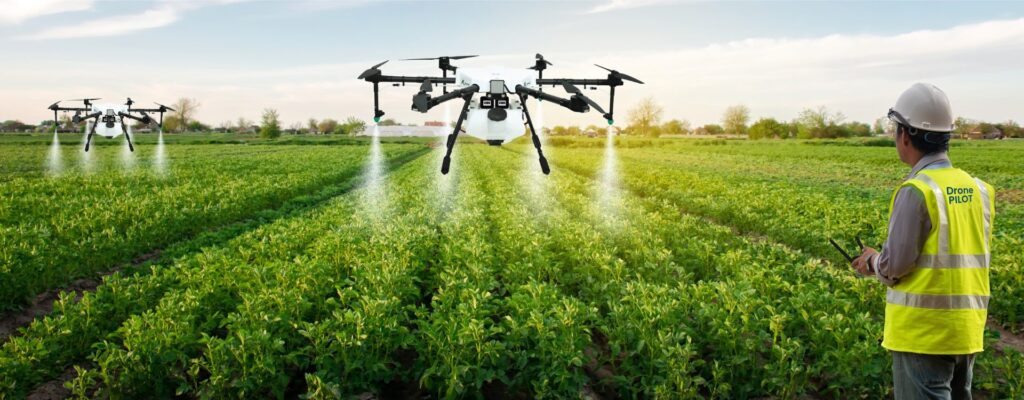
Pest Management: Drones equipped with advanced sensors can detect early signs of pest infestation where GIS analysis helps create maps indicating the areas affected allowing farmers to deploy targeted pest control measures. This proactive approach mitigates crop damage reducing the need for widespread pesticide application.
Yield Prediction: By combining drone imagery with GIS, farmers can generate accurate yield predictions and analyzing historical data, weather patterns and current crop conditions enables the creation of predictive models. This foresight empowers farmers to make informed decisions regarding harvest timing and marketing strategies.
Water Management: Drones equipped with thermal cameras can identify variations in soil moisture levels where GIS technology processes this data to create detailed water management plans and optimizing irrigation practices. Efficient water usage not only conserves a precious resource but also contributes to cost savings for farmers.
Benefits of Drones in Agriculture
Precision Farming: Drones equipped with high-resolution cameras and sensors capture detailed imagery of agricultural fields providing farmers with valuable spatial data and GIS technology then processes this data to create precise maps that highlight variations in soil composition, moisture levels and crop health.
Efficient Monitoring and Crop Management: Traditional methods of crop monitoring often involve time-consuming field visits and manual assessments where drones equipped with GIS technology, however offer real-time and bird’s-eye views of the entire agricultural landscape.
Irrigation Optimization: Water is a precious resource in agriculture and efficient irrigation is crucial for maximizing crop productivity where GIS-enabled drones play a key role in optimizing irrigation by assessing soil moisture levels across the fields. This information helps farmers create irrigation schedules tailored to the specific needs of different areas ensuring that crops receive the right amount of water at the right time.
Crop Health Analysis: GIS technology facilitates the creation of spectral imagery maps allowing farmers to assess crop health based on factors like chlorophyll content and vegetation indices. Drones equipped with multispectral or hyperspectral sensors capture this data enabling the creation of detailed maps that highlight areas of stress or potential diseases.
How Farmers are using Drones in Agriculture?
GIS technology enables farmers to collect and analyze spatial data providing valuable insights for precision agriculture where drones equipped with high-resolution cameras and multispectral sensors capture detailed imagery of crops allowing for real-time monitoring and analysis. This aerial perspective aids in the early detection of crop diseases, nutrient deficiencies and pest infestations enabling timely interventions.
The GIS industry plays a pivotal role in processing the vast amounts of geospatial data collected by these drones and through advanced mapping and spatial analysis, farmers can create detailed maps that highlight variations in soil health, moisture levels and crop health across their fields. This information is invaluable for optimizing resource allocation, ensuring targeted irrigation and minimizing the use of fertilizers and pesticides.
By harnessing the power of GIS-driven drones, farmers can make data-driven decisions to boost productivity, conserve resources and ultimately contribute to sustainable agriculture and as technology continues to advance, the synergy between GIS and drone technology promises to revolutionize the way farmers approach cultivation ushering in a new era of precision and efficiency in agriculture.
Drones equipped with GIS technology have emerged as indispensable tools in modern agriculture offering farmers unprecedented levels of precision and efficiency and by combining GIS mapping, data analytics and remote sensing technologies, farmers may make well-informed decisions that maximize resource utilization, boost yields and advance sustainability. The combination of drone technology and GIS in agriculture has the potential to completely transform farming in the future and bring in a sustainable and precise era as long as regulatory issues are resolved and technological advancements are made.


