What is a digital elevation model (DEM)?
A Digital Elevation Model (DEM) is a representation of the bare ground (bare earth) topographic surface of the Earth excluding trees, buildings, and any other surface objects. GIS is based on Digital Elevation Models (DEMs) which are essential for landscape modeling, terrain analysis and other environmental applications where it gives a thorough grasp of DEMs by exploring their types, definitions, acquisition techniques and uses in the GIS sector.
Digital elevation models or DEMs represent the three-dimensional distribution of terrain elevation values over a given area where the terrain data is essential for many GIS applications such as disaster management, environmental modeling and urban planning. DEMs are a key source of information for determining the important characteristics of the terrain which enables analysts to visualize and analyze landscape elements precisely.
Types of DEM
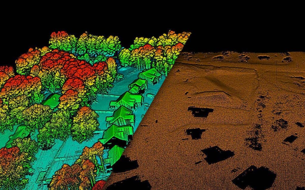
Airborne LiDAR DEMs: Using laser pulses, LiDAR (Light Detection and Ranging) technology measures distances and produces extremely precise elevation models and by installing LiDAR sensors on airplanes, it is possible to create airborne LiDAR DEMs that enable quick and accurate data collecting. Because of their great spatial resolution, the resultant DEMs are perfect for use in infrastructure development, flood modeling and forestry management.
Satellite-based DEMs: Remote sensing technology is used by satellite-derived DEMs to obtain elevation data from space where the global-scale DEMs are partly produced by platforms such as the Advanced Spaceborne Thermal Emission and Reflection Radiometer (ASTER) and the Shuttle Radar Topography Mission (SRTM). Although DEMs derived from satellites provide a large coverage area, their spatial resolution could be inferior to that of LiDAR-based models. Applications for these DEMs include large-scale environmental monitoring, land cover analysis and regional planning.
Structure from Motion (SfM) DEMs: A photogrammetric method called Structure from Motion reconstructs 3D structures from sequences of 2D images and when used in DEM creation, SfM merges overlapping photos captured from various angles to produce precise and intricate terrain models. This method works well for applications such as precision agriculture, landslide analysis and archeological site monitoring as it is affordable and can be used with consumer-grade cameras.
Interferometric Synthetic Aperture Radar (InSAR) DEMs: With the use of radar signals from satellites, InSAR technology measures changes in ground surface elevation with remarkable accuracy and to track subsidence, uplift and other deformations over time. In SAR, DEMs can be created by examining the patterns of radar wave interference. Urban subsidence monitoring, tectonic plate movement and geohazard evaluations all benefit greatly from this kind of DEM.
Terrain Models with Varying Resolutions: Another way to classify DEMs is by their spatial resolution and while low-resolution models cover greater regions but with less detail, high-resolution digital elevation models (DEMs) capture finer aspects of the landscape but may cover smaller areas. In applications like urban planning, environmental impact assessment and natural resource management, this classification is essential for striking a balance between coverage and detail.
Orthorectified DEMs: The technique of orthorectification involves taking out distortions from aerial or satellite pictures that are brought about by sensor geometry and terrain relief. Georeferenced and devoid of geometric errors, orthorectified digital elevation models (DEMs) offer a precise depiction of the Earth’s surface and in applications where precise geographic data is essential such as infrastructure planning, precision agriculture and cartography, these DEMs are commonly employed.
Methods for Acquiring DEMs:
Airborne LiDAR: High-precision elevation data is produced by using reflected laser pulses emitted by LiDAR sensors installed on airplanes to the ground and high-resolution DEM creation and large-scale mapping are made possible by the effectiveness of airborne LiDAR.
Satellite-based DEMs: Elevation data is gathered globally by satellite sensors such as those on board the Shuttle Radar Topography Mission (SRTM) and WorldView satellites. These datasets aid in the creation of DEMs with medium to coarse resolution that are appropriate for regional and international applications.
Photogrammetry: To extract elevation information, photogrammetry entails interpreting stereo pairs of aerial or satellite photos and this technique is popular and economical for mapping a variety of terrains.
Important Technical Words:
Z-Values: The elevation values that are allocated to each point in a DEM are represented by Z-values where comprehending Z-values is essential for precise analysis and description of terrain.
Interpolation: To estimate elevation values between known data points, interpolation techniques like kriging and inverse distance weighting are used. These techniques improve DEMs’ spatial resolution.
Spatial Resolution: In a DEM grid, the size of individual cells or data points is referred to as spatial resolution. More comprehensive topographical information can be obtained with higher spatial resolution, although this may necessitate more processing and storage power.
Aspect: An aspect is a terrain surface’s orientation and it is an essential parameter for comprehending the properties of the slope and the distribution of solar radiation.
Slope: Slope expresses how steep the surface of the land is and slope analysis is necessary for applications such as hydrological modeling and land suitability assessment.
Hillshade: This method mimics the shading effects of sunlight to help visualize topographical features and it improves DEMs’ three-dimensional vision.
DEMs applications in GIS:
Hydrological Modeling: The creation of stream networks, the determination of watershed borders and flow direction are all made possible with the help of DEMs.
Terrain Analysis: GIS experts classify landforms, map land cover and conduct geological research using DEMs for terrain analysis.
Viewshed Analysis: This technique helps choose sites for a variety of uses including surveillance systems and telecommunications towers, by using digital elevation models (DEMs) to identify observable areas from particular locations.
3D Visualization: By facilitating the production of lifelike 3D representations, DEMs improve the understanding of spatial data and aid in the process of making decisions.
Natural Resource Management: By offering information on elevation differences, assisting with forest management, predicting soil erosion and promoting biodiversity conservation, DEMs support the management of natural resources.
Digital elevation models are invaluable resources in the GIS field since they offer a precise depiction of the surface of the planet and with a wide range of forms and techniques of acquisition, DEMs enable GIS specialists to perform accurate terrain assessments and facilitate decision-making in multiple industries. The combination of DEMs with cutting-edge methods like machine learning holds great promise for expanding their use and influence in the rapidly developing field of geospatial science especially as technology continues to advance. To fully utilize DEMs and help shape our understanding of Earth’s dynamic landscapes, one must have a sophisticated understanding of the technical words that are linked with them.


