Technology has become a key factor in today’s agricultural scene guiding the sector toward previously unheard-of levels of sustainability and efficiency and one such pair of technologies that have become more well-known is Geographic Information Systems (GIS) and Remote Sensing (RS). The way farmers and agricultural professionals approach land management, crop monitoring and decision-making processes has changed dramatically as a result of these innovative instruments.
Remote Sensing in Agriculture
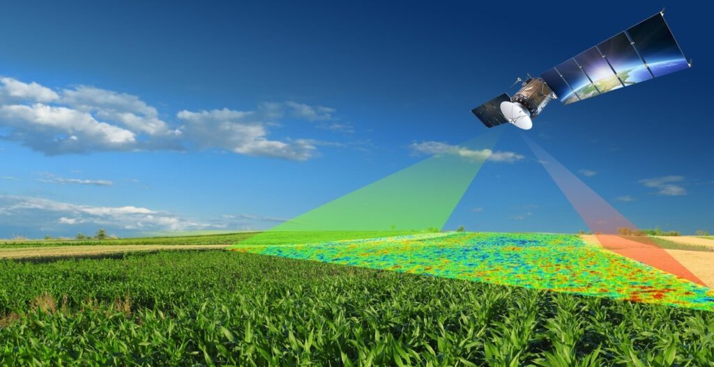
The process of gathering data about a thing or phenomenon without making direct physical contact is known as remote sensing which is used in agriculture to gather data about the Earth’s surface using a variety of sensors, usually installed on satellites or unmanned aerial vehicles (UAVs).
Types of Remote Sensing:
- Passive Remote Sensing: This technique collects data by relying on radiation from the outside world, including sunshine where typical passive sensors are radiometers and cameras.
- Active Remote Sensing: In this method, sensors release radiation of their own and gauge the reaction whereas active sensors include LiDAR (Light Detection and Ranging) and radar.
GIS in Agriculture
GIS is a powerful tool for spatial analysis, data management and visualization and in agriculture, GIS integrates various data sources facilitating a holistic understanding of the landscape.
Spatial Data in GIS:
- Vector Data: Utilizes points, lines and polygons to represent features on the Earth’s surface where fields, roads and infrastructure can be mapped using vector data.
- Raster Data: Represented as a grid of cells, each with a specific value, raster data is crucial for mapping continuous phenomena like temperature, precipitation and soil moisture.
Crop Yield Estimation and Crop Risk Detection
Using technology to its full potential is essential for sustainable and effective crop management in the modern era of agriculture and the integration of Geographic Information Systems (GIS) with Remote Sensing (RS) for precise agricultural yield estimation and risk identification is one such ground-breaking method. Utilizing satellite and aerial photography, remote sensing gathers information on a range of surface features. This technology is essential for evaluating crop health tracking growth patterns and spotting any hazards in the agricultural setting. By offering a geographical foundation for organizing and evaluating this data, GIS enhances RS and helps to create a full precision agriculture system.
A key component of agricultural planning and crop yield estimation is substantially improved by RS and GIS and through the analysis of satellite-captured spectral signatures, these technologies allow farmers to evaluate the health of their crops. With the use of multispectral and hyperspectral images, small changes in plant health can be detected enabling focused actions. Then, using GIS, this data is transformed into insights that can be put into practice producing intricate maps that show locations with high and low yield potential and with the use of this knowledge, farmers are better equipped to allocate resources efficiently and raise total productivity.
Efficient Field Visits: Precision agriculture has been revolutionized by the integration of Remote Sensing and Geographic Information Systems where this technology reduces the need for frequent field visits enhancing the accuracy and efficiency of agricultural operations. Satellite and aerial imagery provide a bird’s-eye view of agricultural landscapes allowing GIS software to process and analyze this data. Technologies like NDVI and drones capture real-time data on crop conditions allowing for comprehensive analysis without the need for field visits. GIS also allows for detailed maps to optimize resource allocation and yields minimizing costs and environmental impact.
Study of Growth Cycle of a Crop: Precision agriculture has been significantly enhanced by the integration of Remote Sensing (RS) and Geographic Information Systems (GIS) where RS technologies provide high-resolution imagery for monitoring crop health and assessing environmental conditions and GIS allows for spatial analysis of agricultural data enabling detailed maps of crop distribution and soil properties. It also aids in temporal analysis tracking changes in crop conditions over time. GIS techniques aid in data-driven decisions, such as crop yield prediction and pest infestation identification.
Crop Insurance Management and Crop Health Monitoring
The integration of Remote Sensing (RS) and Geographic Information Systems (GIS) in agriculture has revolutionized crop health monitoring and insurance management where RS allows farmers to acquire real-time data about their crops enabling the detection of subtle changes in crop health. GIS provides a spatial context to this data allowing farmers to analyze and interpret it in a geospatial framework. NDVI or Normalized Difference Vegetation Index is a crucial metric derived from RS data indicating crop vitality. GIS overlays this information onto spatial maps enabling farmers to pinpoint areas requiring attention and implement targeted interventions and the integration of RS and GIS also helps in crop insurance management allowing insurers to conduct more precise risk assessments and customize policies based on actual risk exposure. RS and GIS also contribute to early warning systems predicting potential threats to crops and enabling farmers and insurers to proactively mitigate risks, ultimately safeguarding agricultural productivity.
Precision, efficiency and sustainability have become the hallmarks of a new era marked by the integration of GIS and remote sensing where farmers and agricultural specialists are empowered to make data-driven decisions by the technological complexities of these technologies which range from spectral bands to spatial data integration. The combination of remote sensing and geographic information systems is expected to become more and more important in tackling the issues posed by an expanding world population and guaranteeing food security for future generations as technology develops.


