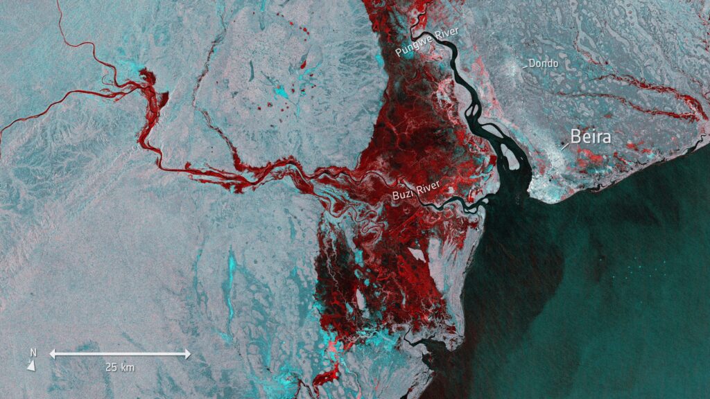
Synthetic Aperture Radar SAR is an active remote sensing technology that utilizes microwave signals to acquire detailed and precise images of the Earth’s surface and unlike optical sensors that rely on sunlight, SAR operates independently of weather conditions and can capture data day or night. The “synthetic aperture” refers to the creation of a virtual antenna aperture by moving a physical antenna along the flight path of an airborne or spaceborne platform. The radar transmits microwave pulses towards the Earth’s surface and the echoes from these pulses are recorded where the recorded signals are then processed to create high-resolution images offering a unique perspective that complements optical and other remote sensing data. SAR data, therefore, encompasses the information obtained from these radar signals and the subsequent processing steps that transform raw data into interpretable images.
Applications of SAR Data in GIS
Land Cover Classification: SAR data is widely employed in land cover classification due to its ability to penetrate clouds and vegetation where the distinctive backscatter signatures of different land cover types, as captured by SAR, enable accurate classification and mapping of urban areas, agricultural fields, forests and water bodies.
Disaster Monitoring and Response: SAR data plays a crucial role in disaster monitoring and response efforts and in the aftermath of natural disasters such as earthquakes, floods or hurricanes, SAR imagery helps assess the extent of damage, identify areas of displacement and facilitate rapid response planning. The all-weather capability of SAR is particularly valuable in emergencies where optical sensors may be hindered by adverse weather conditions.
Environmental Monitoring; SAR technology contributes significantly to environmental monitoring by providing detailed information on changes in vegetation structure, soil moisture and land deformation. This is particularly relevant for applications such as deforestation detection, wetland mapping and monitoring the impact of climate change on the Earth’s surface.
Infrastructure Monitoring: SAR data is employed in monitoring critical infrastructure such as bridges, dams and pipelines and by detecting subtle deformations or movements in infrastructure components, SAR aids in the early identification of potential issues contributing to the maintenance and safety of essential structures.
Levels of SAR Data
Level-0 SAR Data: At its rawest form, Level-0 SAR data represents the unprocessed radar signal received by the satellite sensor and this data contains the raw radar echoes and other auxiliary information such as spacecraft and sensor parameters. Level-0 data is essential for further processing and calibration but is rarely used directly in GIS applications due to its complexity.
Level-1 SAR Data: Level-1 SAR data marks the beginning of data processing for practical applications and it involves the calibration of Level-0 data to correct for sensor-specific artifacts and atmospheric effects. Calibration transforms the raw radar signal into calibrated radar backscatter values, measured in decibels (dB). Level-1 data is essential for basic applications like topographic mapping and change detection.
Level-2 SAR Data: Moving up the processing ladder, Level-2 SAR data involves further refinement and enhancement and this level includes the geocoding process where radar imagery is transformed into geographic coordinates using precise orbit and Digital Elevation Model (DEM) information. Level-2 data is often used for regional mapping, land cover classification and environmental monitoring.
Level-3 SAR Data: Level-3 SAR data involves the compilation and synthesis of multiple Level-2 SAR datasets for broader analysis and it includes the generation of mosaics or time-series datasets facilitating the monitoring of long-term changes in the Earth’s surface. Level-3 data is crucial for applications such as crop monitoring, deforestation analysis and infrastructure development planning.
Level-4 SAR Data: The highest level of processed SAR data, Level-4, focuses on specific applications or customized products and this level often involves data fusion with other remote sensing sources such as optical imagery or thermal data, to provide comprehensive and detailed information for specialized studies. Level-4 data is employed in applications like disaster management, precision agriculture and urban planning.
A mainstay of the GIS sector, Synthetic Aperture Radar (SAR) data provides a distinct viewpoint on the surface of the Earth and its great spatial resolution, versatility and all-weather capabilities make it an essential instrument for tracking and comprehending our planet. The combination of SAR and GIS will surely spur innovation and advance our capacity to handle difficult problems about environmental change, disaster relief and sustainable development as technology develops.


