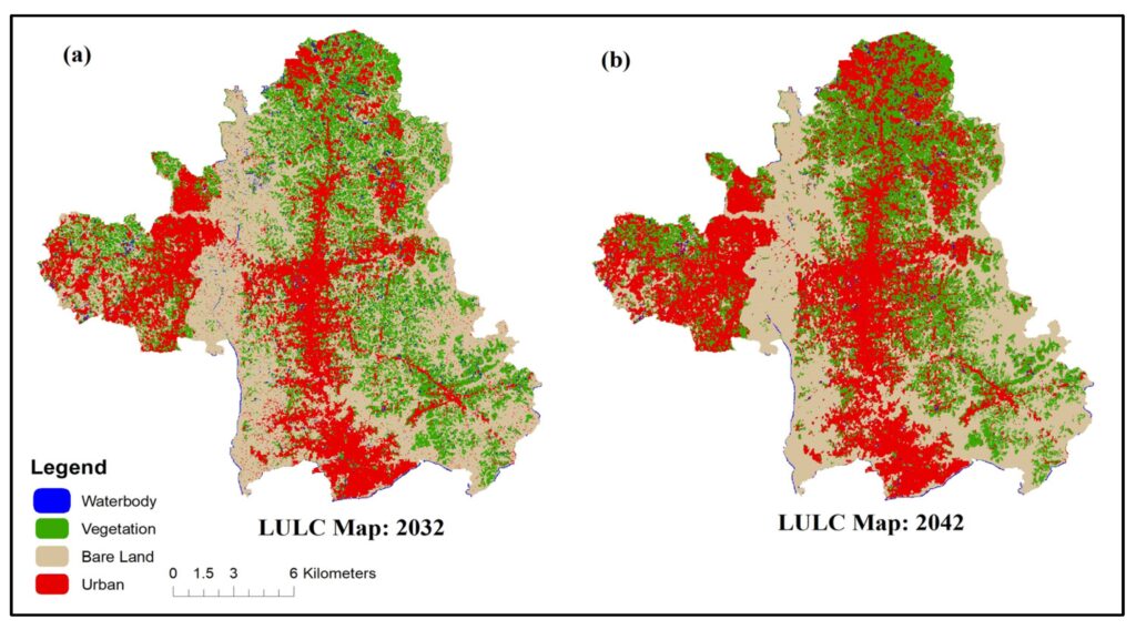
The term Land Use and Land Cover (LULC) refers to the physical and human characteristics-based classification and categorization of the Earth’s surface. In this comprehensive study, the physical characteristics of the land surface (Land Cover) and how land is used (Land Use) are identified. LULC is an important topic when it comes to Geographic Information Systems (GIS). Geographic information systems (GIS) are crucial for mapping and examining LULC trends as well as for learning more about the dynamic relationships between anthropogenic and natural factors that affect our environment. The functional and physical properties of the Earth’s surface are described by the terms “land use” and “land cover,” or LULC for short. These concepts are crucial to comprehending spatial dynamics and are basic to both cartography and GIS analysis.
Defination: Land Use: Land Use is a category classification that describes how people use a certain region of land where it includes a wide range of purposes including institutional, commercial, industrial, agricultural, recreational and residential. Land Use is shown in GIS as a thematic layer with distinct codes or symbols allocated to each category for geographical analysis. The physical features and surface characteristics of the Earth’s landscape are referred to as land cover. This covers both man-made features like buildings, roads and urban infrastructure as well as natural aspects like forests, water bodies and bare soil and remote sensing data and pictures are frequently used to illustrate land cover giving a visual depiction of the composition of the Earth’s surface.
Methods in LULC
Remote Sensing: Utilizing satellite or aerial imagery, remote sensing captures data from a distance where spectral bands help differentiate land cover types based on reflectance characteristics enabling the creation of detailed LULC maps.
Supervised Classification: GIS analysts employ machine learning algorithms to classify pixels based on predefined training samples where this method enhances accuracy by training the algorithm to recognize specific land cover signatures.
Unsupervised Classification: This method involves grouping pixels without predefined classes and clusters of similar spectral characteristics are identified aiding in the discovery of hidden patterns and facilitating LULC classification.
Object-Based Image Analysis (OBIA): Instead of pixel-based analysis, OBIA focuses on image objects, considering spatial relationships where this method improves accuracy by incorporating contextual information, leading to more refined land cover classifications.
Change Detection: Monitoring alterations in land use over time is vital and change detection methods, such as image differencing or NDVI analysis, highlight areas transforming, aiding in understanding dynamic LULC patterns.
Some Advantages
Urban Development and Spatial Planning: LULC in GIS offers crucial insights to legislators and urban planners by supporting the creation of spatial plans and it makes it possible to determine the best locations for residential zones, green spaces and infrastructural development. Cities may ensure sustainable growth and effective resource allocation by optimizing land utilization through the examination of land use trends.
Environmental Conservation: Monitoring and managing natural resources is made possible through the use of GIS-based LULC analysis where environmentalists can map land covers including forests, wetlands and agricultural areas to determine how human activity affects ecosystems and the implementation of conservation measures and the preservation of biodiversity depend heavily on this information.
Climate Change Assessment: Understanding the effects of climate change requires a thorough understanding of LULC analysis and by tracking how land cover changes over time, GIS technology makes it easier to identify regions that are vulnerable to environmental degradation. Strategies to lessen the effects of climate change such as reforestation projects and sustainable land management techniques can be developed with the use of this information.
Disaster Risk Management: The use of LULC in GIS applications is essential for disaster risk reduction where authorities can create efficient plans for responding to disasters by mapping areas that are susceptible to damage and identifying potential hazards. To lessen the effects of natural disasters, for example- mapping land covers in areas prone to flooding enables the deployment of early warning systems and evacuation preparations.
Future Trends
Land Use and Land Cover (LULC) dynamics are undergoing a transformative evolution, driven by advancements in Geographic Information System technologies where the future trends of LULC are characterized by precision, automation, and integration, revolutionizing how we perceive and manage our environment.
Machine learning algorithms are increasingly being employed for accurate land cover classification enabling the extraction of valuable information from satellite imagery with unprecedented accuracy where high-resolution satellite data coupled with LiDAR technology facilitates the creation of detailed 3D models enhancing our understanding of land use patterns.
The integration of LULC data with other geospatial datasets such as climate and socioeconomic factors is becoming paramount where this holistic approach enables comprehensive analysis and informed decision-making in urban planning, resource management and environmental conservation.
Real-time monitoring using Earth observation satellites allows for timely detection of land cover changes, aiding in disaster management and climate change adaptation. Additionally, the emergence of blockchain technology is enhancing data security and transparency in handling large-scale LULC datasets.
Using GIS technology to map land use and land cover is a crucial tool for managing and comprehending our environment. Making educated decisions is aided by the insights gained via LULC analysis which may be used for anything from urban planning to environmental conservation. The assimilation of sophisticated GIS methodologies, artificial intelligence and enhanced data resolution will bolster our capacity to oversee and regulate the ever-changing topographies that mold our planet as technology advances.


