The persistent pursuit of state-of-the-art satellite technology in the field of Geographic Information Systems (GIS) has given rise to innovative platforms, with KazEOSat leading the way. The National Company “Kazakhstan Gharysh Sapary” (KGS) created this cutting-edge Earth observation satellite, which has completely changed the way that geospatial data is acquired and analyzed. This article explores the design, capabilities, and revolutionary effects of KazEOSat on the GIS sector, delving into the technical details of the satellite.
Technical details:
Altitude and Orbit: Because KazEOSat is in a sun-synchronous orbit, it can take pictures under constant lighting. At an altitude of roughly 600 kilometers, the satellite usually cruises at a perfect balance between coverage and spatial resolution.
Imaging Device: The core of KazEOSat’s power is its sophisticated imaging system. The satellite’s high-resolution optical sensors allow it to take remarkably accurate multispectral and panchromatic images. The visible, near-infrared, and shortwave infrared spectra are among the multispectral bands that allow for a thorough examination of the surface features of the Earth.
Resolution and Swath Width: The spatial resolution of KazEOSat is remarkable, frequently extending to sub-meter levels. Because of its ability to detect even the smallest details on Earth’s surface, this makes it a priceless instrument for a variety of uses, from agricultural monitoring to urban planning. The satellite’s broad sweep width further guarantees effective coverage, increasing its usefulness for large-scale mapping and disaster relief.
Review Period: KazEOSat’s sophisticated propulsion system and nimble orbit allow it to accomplish an amazing revisit time. The capacity to quickly return to particular locations is essential for activities like documenting land use trends, keeping an eye on changing environmental conditions, and reacting quickly to catastrophes.
Uses:
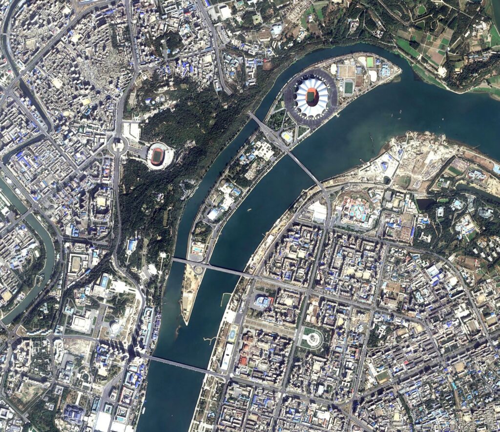
Infrastructure Development and Urban Planning: The utilization of high-resolution pictures from KazEOSat has revolutionized the field of urban planning and infrastructure development. It makes it possible to map metropolitan areas in great detail, which makes it easier to plan land use, evaluate infrastructure, and find possible development locations.
Agricultural Surveillance: KazEOSat is essential to precision farming, yield estimation, and crop monitoring in the agricultural industry. The evaluation of vegetation health, detection of pest infestations, and improvement of irrigation techniques are all made possible by the multispectral capabilities.
Environmental Surveillance: KazEOSat records changes in land cover, deforestation, and the effects of climate change, all of which greatly aid in environmental monitoring. Assessing ecosystem health and identifying at-risk areas is made easier by the satellite’s capacity to collect data in a variety of spectral bands.
Disaster Management: KazEOSat’s high-resolution imagery and quick revisit time make it a priceless tool for disaster management. The satellite is essential for improving resilience and response capacities since it can be used to measure the extent of natural catastrophes like floods, earthquakes, and wildfires as well as assist with post-disaster recovery operations.
Connecting to GIS Platforms:
Accessibility of Data: Users can easily obtain KazEOSat’s extensive dataset thanks to its smooth integration with GIS applications. Cloud-based services guarantee that geospatial experts may access, process, and display satellite imagery in their favorite GIS settings.
Data Analysis and Processing: Sophisticated processing is applied to the raw imagery from KazEOSat to improve the overall quality and adjust for atmospheric aberrations and geometric image correction. Once this data has been processed, it can be used with GIS software to create precise geospatial models, perform in-depth spatial analysis, and detect changes.
Open Data Projects: KazEOSat actively takes part in open data projects because it understands the collaborative aspect of GIS. The satellite promotes international cooperation in research, development, and disaster response by contributing to a worldwide repository of geographic information by making part of its data publicly available.
Prospects & Innovations for the Future:
Progress in Sensing Technology: The GIS sector is ever-changing, and KazEOSat is no exception. Continuous improvements in sensor technology could result in even greater spectral and spatial resolutions, broadening the scope of possible uses and increasing the accuracy of data interpretation.
Integration of artificial intelligence: KazEOSat is probably going to incorporate AI algorithms for automatic feature recognition, change detection, and anomaly identification as AI continues to advance in the field of geospatial research. This will expedite the process of deriving significant insights from the copious amounts of data that the satellite has collected.
International Cooperation: International cooperation is essential to the future of Earth observation. With its strategic location, KazEOSat is expected to play a major role in international projects tackling global issues including deforestation, climate change, and disaster relief. Data exchange, cooperative research collaborations, and the creation of defined protocols for satellite data interoperability are all examples of collaborative activities.
KazEOSat is proof of the Earth observation satellites’ ever-growing potential in the GIS sector. The technological capabilities of this tool, along with its numerous uses, have raised the bar for geospatial data analysis and gathering. Future developments combined with the incorporation of KazEOSat into GIS workflows hold the potential to open up new avenues for comprehending the dynamic landscape of Earth. Not only is KazEOSat’s voyage a scientific marvel, but it is also a revolutionary force that will shape geospatial intelligence in the future.


