The term Synthetic Aperture refers to the technique SAR uses to achieve high spatial resolution where by moving the radar along a flight path and combining the signals over time, Synthetic Aperture Radar effectively synthesizes a large antenna aperture increasing the resolution beyond what a real antenna of similar size could achieve. This results in highly detailed images, often with spatial resolutions as fine as one meter or better.
Key Technical Concepts of SAR
Backscatter Coefficient (σ°): The backscatter coefficient, also known as sigma nought (σ°), is a measure of the radar signal’s intensity reflected by the Earth’s surface. It is typically expressed in decibels (dB) and is critical for interpreting SAR data. The backscatter coefficient depends on various factors, including surface roughness, dielectric properties, and the angle of incidence of the radar signal. In GIS, σ° values help in classifying land cover types, detecting surface changes, and monitoring phenomena like soil moisture, flooding, or deforestation.
Polarimetry: Polarimetry in SAR refers to the analysis of the polarization states of radar signals, which can be either horizontally or vertically polarized. Dual-polarization (HH, HV, VV, VH) and quad-polarization SAR systems capture data in different polarization combinations, providing additional information about surface features. Polarimetric SAR (PolSAR) is especially valuable in differentiating between vegetation types, soil conditions, and built-up areas. For instance, double-bounce scattering from buildings produces distinct polarimetric signatures compared to volume scattering from forests enabling accurate land cover classification in GIS.
Interferometry: SAR interferometry (InSAR) is a technique that utilizes two or more SAR images taken from slightly different positions to measure surface displacement and by comparing the phase differences between the images, InSAR can detect ground movement with centimeter-level accuracy. This technique is widely used in monitoring earthquakes, landslides, subsidence, and glacier movements. In GIS, InSAR data can be integrated with other spatial datasets to assess risk and develop mitigation strategies for geohazards.
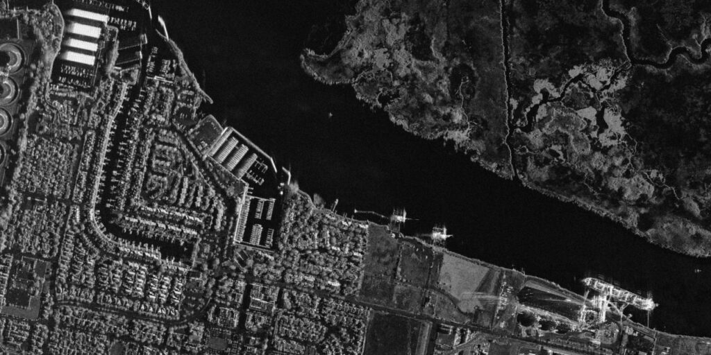
Resolution: Resolution in SAR refers to the level of detail that can be observed in the resulting imagery. SAR resolution can be divided into two components: range resolution and azimuth resolution. Range resolution is determined by the pulse width of the radar signal and the slant range distance, while azimuth resolution is controlled by the synthetic aperture process. High-resolution SAR systems can capture fine details such as individual buildings, vehicles, and infrastructure, which are invaluable for urban mapping, disaster response, and infrastructure monitoring in GIS.
Speckle: Speckle is a type of granular noise inherent in SAR images due to the coherent nature of radar signals. It occurs when the radar signal reflects off multiple small surface elements within a single pixel, causing constructive and destructive interference. While speckle can reduce the visual quality of SAR images, it also carries useful information about surface roughness and heterogeneity. GIS professionals often apply speckle filtering techniques, such as the Lee or Frost filter, to improve the interpretability of SAR data while preserving important details.
As SAR technology continues to evolve, with advancements in polarimetry, interferometry, and data processing, its role in the GIS industry will only grow. By integrating SAR data with other spatial datasets, GIS professionals can develop more accurate models, make informed decisions, and contribute to the sustainable management of natural resources and infrastructure. Despite the challenges associated with SAR data interpretation and processing, the benefits of this powerful technology far outweigh the limitations, making SAR an essential tool for the future of GIS and Earth observation. SAR’s unique capabilities have revolutionized how we monitor and understand the Earth’s surface, providing critical insights for decision-makers across a wide range of industries. With
continued advancements in SAR technology and the increasing availability of SAR data, the GIS community is well-positioned to harness the full potential of this innovative remote sensing tool.


