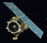
GeoEye-1

GeoEye-1
Launched in 2008 with a resolution of 0.41 m at nadir.Highest accuracy in horizontal and vertical directions.
Design and specifications
| Launch Information | Date: September 6, 2008 Launch vehicle: Delta II Launch site: Vandenberg Air Force Base, California |
| Mission Life | Expected >10 years |
| Spacecraft Size | 4186 lbs, 4.34m in length |
| Orbit | Type: Sun-synchronous,
10:30 am descending node Period: 98 min |
| Sensor Resolution and Spectral Bandwidth | Panchromatic: 41 cm GSD at nadir Black & White: 450 – 800 nm Multispectral: 1.65 m GSD at nadir Blue: 450 – 510 nm Green: 510 – 580 nm Red: 655 – 690 nm Near-IR: 780 – 920 nm |
| Dynamic Range | 11-bits per pixel |
| Swath Width | Nominal Swath Width: 15.3 km at nadir |
| Attitude Determination and Control | Type: 3-axis Stabilized Star tracker/IRU/reaction wheels, GPS |
| Retargeting Agility | Time to slew 200 km: 20 sec |
| Onboard Storage | 1 Tbit capacity |
| Communications | Payload Data: X-band 740/150 Mbps AES/DES encryption
Housekeeping: X-band 64 kbps AES encryption |
| Revisit Frequency (at 40°N Latitude) | 2.6 days at 30° off-nadir |
| Metric Accuracy | 5 m CE90, 3 m CE90 (measured) |
| Capacity | 350,000 km 2/day Multi-spectral |