WorldView-1
Satellite Imagery
SATPALDA provides clear and timely insights into our ever-changing worldthrough high-quality satellite imagery.Our satellite images are sourced from trusted partner companies,ensuringaccuracy and reliability for diverse applications.
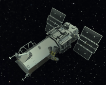
WorldView-1
Launched in 2007 with a resolution of 0.50 m at nadir.Excellent panchromatic imagery with a stereo option.
Specifications of WorldView-1 sensor
| Launch Information | Date: September 18, 2007 Launch Vehicle: Delta II 7920 Launch Site: Vandenberg Air Force Base |
| Orbit | Altitude: 496 kilometers Type: Sun synchronous, 10:30 am descending node Period: 94.6 minutes |
| Sensor Bands | Panchromatic |
| Sensor Resolution(GSD) | 0.50 meters GSD at nadir 0.59 meters GSD at 25° off-nadir |
| NIIRS Equivalency: | NIIRS potential of greater than 5.0 |
| Dynamic Range | 11-bits per pixel |
| Swath Width | 17.6 kilometers at nadir |
| Pointing Accuracy & Knowledge Accuracy: | <500 meters at image start and stop |
| Knowledge | Supports geolocation accuracy |
| Retargeting Agility | Acceleration: 2.5 deg/s/s Rate: 4.5 deg/s Time to slew 300 kilometers: 10.5 seconds |
| On-board Storage | 2199 gigabits solid state with EDAC |
| Max Viewing Angle / Accessible Ground Swath | Nominally +/-45° off-nadir = 1036 km wide swath Higher angles selectively available |
| Per Orbit Collection | 331 gigabits |
| Max Contiguous Area Collected in a Single Pass | 60 x 110 km mono 30 x 110 km stereo |
| Revisit Frequency | 1.7 days at 1 meter GSD 4.6 days at 25° off-nadir or less (0.59 meter GSD) |
| Geolocation Accuracy (CE90) | 6.5m CE90% at nadir. Actual accuracy – 4.0 – 5.5m CE90% (excluding terrain and off-nadir effects) |